Search Now
Sikkim Wildfire Spread Forecasting and Monitoring System (SWFMS)
- Home
- Applications
- Projects
- Sikkim Wildfire Spread Forecasting and Monitoring System (SWFMS)
About Project
C-DAC has developed a unique operational Sikkim Wildfire Spread Forecasting and Monitoring System (SWFMS) for the state of Sikkim in collaboration with Department of Science and Technology, Sikkim and Indian Institute of Technology, Kharagapur. The SWFMS has been developed under the project funded by Ministry of Electronics and Information Technology, Govt. of India.
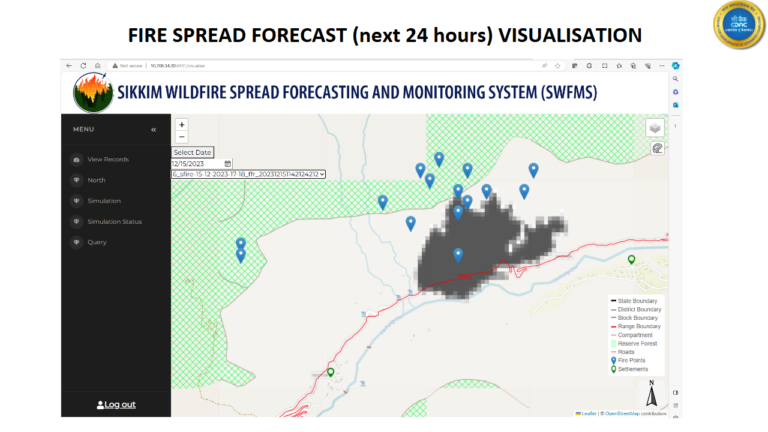
The system facilitates forest fire spread forecasting up-to next 48 hours after the fire ignition location is detected (either through satellites or by the field staff). The open source coupled atmosphere-wildfire model (WRF SFIRE) has been used to simulate forest fire. The system require information about fire ignition location, fuel parameters, landuse landcover map, elevation and forecasted atmospheric data. The system can be deployed on PARAM series of supercomputers.
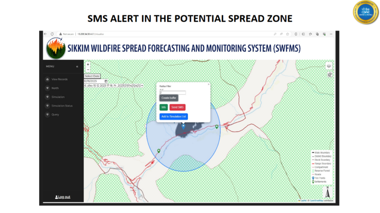
User need internet connectivity to fire the simulation job on remote High Performance Computing (HPC) system by feeding in easily available inputs i.e. ignition location, date and time of fire and the duration for which simulation needs to be carried out. The job is executed on HPC and results (fire spread area) are sent back to the user. User can visualise the fire spread area in Geographical Information System (GIS) and send the SMS alerts to the registered user in the specified buffer area.
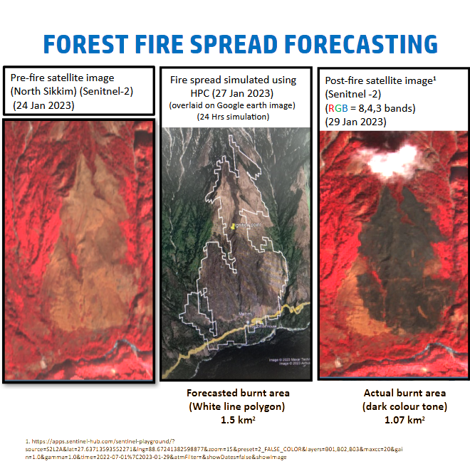
The Sikkim Forest Department has used the forecasted outputs for the forest fires happened on 27 January 2023 and 12 March 2024 and found the system useful in forest fire spread management.
Objectives
Development and deployment of Forest Fire Spread Forecasting System in the state of Sikkim
Application
- Forest fire spread forecasting (uo-to next 48 hours)
- Proximity based SMS alert (useful in sensitising the registered users only in the potentially affected area and thus avoiding the panicky to the unrelated population)
- GIS depiction of the forecasted forest fire spread area (helpful in instantly visualising the potential forest fire spread in map form and strategies the actions to be taken)
- Realtime field assistance to control the spreading wildfire. (The .kml version of the potential fire spread help in easy dissemination of information to the field staff and facilitate visualisation of potential fire spread area in google earth).


Milestones
Development of Forest Fire Spread Forecasting and Monitoring System (SWFMS) (Achieved)
Achievements
Forest fire spread forecasts successfully used for on ground control of spreading wildfire (12 March 2024 and 27 January 2023)
Publications
- Manish P. Kale, Sri Sai Meher, Manoj Chavan, Vikas Kumar, Md. Asif Sultan, Priyanka Dongre, Karan Narkhede, Jitendra Mhatre, Narpati Sharma, Bayvesh Luitel, Ningwa Limboo, Mahendra Baingne, Satish Pardeshi, Mohan Labade, Aritra Mukherjee, Utkarsh Joshi, Neelesh Kharkar, Sahidul Islam,Sagar Pokale, Gokul Thakare, Shravani Talekar, Mukunda-Dev Behera , D. Sreshtha, Manoj Khare,Akshara Kaginalkar, Naveen Kumar and Parth Sarathi Roy Operational Forest-Fire Spread Forecasting Using the WRF-SFIRE Model, Remote Sens. 2024, 16(13), 2480. https://doi.org/10.3390/rs16132480
- Satyajit Behera, Basanta Kumar Prusty, Mukunda Dev Behera, Manish Prabhakar Kale Characterizing fuel flammability in a tropical dry community forest in Eastern India using laboratory and remote sensing-based approaches, Trop Ecol 65, 399–411 (2023). https://doi.org/10.1007/s42965-023-00309-6
- Sujoy Mudi, Somnath Paramanik, Mukunda Dev Behera, A Jaya Prakash, Nikhil Raj Deep, Manish P. Kale, Shubham Kumar, Narpati Sharma, Prerna Pradhan, Manoj Chavan, Partha Sarathi Roy & Dhiren G. Shrestha Moderate resolution LAI prediction using Sentinel-2 satellite data and indirect field measurements in Sikkim Himalaya, Environ Monit Assess 194, 897 (2022). https://doi.org/10.1007/s10661-022-10530-w
Feedback/testimonials
Forest department Sikkim has provided feedback in the form of report and letters regarding the utility of the system in controlling the spreading wildfire
Collaborators/Partners
- Department of Science and Technology, Gangtok, Sikkim
- Centre for Oceans, Rivers, Atmosphere and Land Sciences (CORAL), Indian Institute of Technology, Kharagpur West Medinipur – 721 302, West Bengal, INDIA
End Users/Stakeholders
- Forest department, Sikkim
Contact
Head of the Department ESEG, C-DAC, Pune.
Phone: 020 – 25503233